Indiana is a state in the Midwestern region of the United States of America, whereas Montana is a state in the Mountain West subregion of the Western United States of America. Today in this article, we will discuss the comparison between Indiana and Montana regarding various aspects.
Size
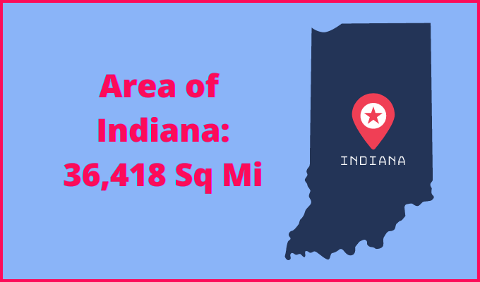
Is Indiana bigger than Montana?
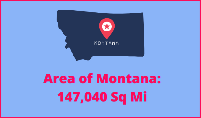
The total area of Indiana is 36,418 sq mi, and the total area of Montana is 147,040 sq mi. Indiana is smaller than Montana by 110,622 sq mi. Indiana is around 4.04 times smaller than Montana.
Area of Indiana: 36,418 sq mi ( 94,321 km2 )
Area of Montana: 147,040 sq mi ( 380,800 km2 )
Population
According to the United States Census Bureau, the total population of Indiana as of 1st July 2021 was estimated to be around 6,805,985.

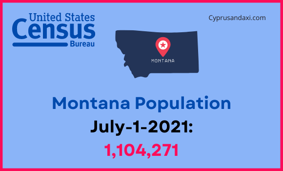
Based on the data provided by the United States Census Bureau, the total population of Montana as of 1st July 2021 was estimated to be around 1,104,271.
Here is some more data comparison between Indiana and Montana.
The capital city of Indiana is Indianapolis, and the capital city of Montana is Helena.
Largest City
Indiana: Indianapolis
Montana: Billings
Demonym(s)
Indiana: Hoosier
Montana: Montanan
Official Languages
Indiana: English
Montana: English
ISO 3166 Code
Indiana: US-IN
Montana: US-MT
Human Development Index
HDI of Indiana as of 2019: 0.912
HDI of Montana as of 2019: 0.921
Indiana Time Zone:
(80 Counties)
UTC – 5 (Eastern Standard Time Zone)
Summer (DST):
UTC – 4 (Eastern Daylight Time)
(12 Counties)
UTC – 6 (Central Standard Time)
Summer (DST):
UTC – 5 (Central Daylight Time)
Montana Time Zone:
UTC − 7 (Mountain Standard Time)
Summer (DST):
UTC − 6 (Mountain Daylight Time)
Geological Coordinates
Coordinates of Indiana:
39° 53′ 39.12″ N, 86° 16′ 53.76″ W
Coordinates of Montana:
47° 3′ 9.72″ N, 109° 37′ 59.88″ W
You may also like to read:
Indiana vs Mississippi Comparison
